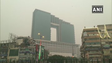
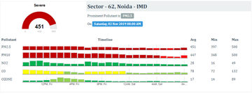
Thick smog continued to engulf two NCR cities – Noida and Ghaziabad – on Saturday with pollution levels in the ‘severe’ category.
The Air Quality Index (AQI)in Noida was recorded at 451 and at 449 in Ghaziabad’s Indirapuram area in the morning, reports news agency ANI.
On Friday, Noida’s AQI spiked to 499 as recorded by the Central Pollution Control Board (CPCB) on a scale of 0 to 500, making it the most polluted city in the country.
According to CPCB, the average particulate matter PM2.5 — the major pollutant — touched an all-time high, ranging from 468.26µg/m3 to 523.49µg/m3, which is seven to eight times higher than the national limit of 60µg/m3.
Greater Noida Friday recorded an AQI of 496, tying in with Ghaziabad as the second most polluted region in India, up from 473 on Thursday. The AQI of Noida, a day earlier was 452.
“We are observing that the pollution levels in Ghaziabad have dropped since 3am Friday, while in Noida it started increasing. Now, given that offences like open burning and local emissions are almost the same across the region, and nothing major has happened locally to increase emissions over the past 24 hours, the most possible factor for the spike is a change in the wind pattern. Both Ghaziabad and Noida share borders with Delhi, from where the winds are coming. While the earlier wind direction, with minor variations, was mostly towards Ghaziabad, the latest pattern is towards Noida. We are still looking into these factors for a deeper understanding,” Utsav Sharma, environmental engineer and regional officer UPPCB, Ghaziabad, said on Friday.
“Yes, the crop stubble burning in Punjab and Haryana is very high, but there are also local emissions to blame. The wind speed is low, about two metres per second, and that is keeping the pollutants from dispersing,” Shambhavi Shukla, programme manager, Centre for Science and Environment (CSE), said.
While the weather and pollution experts believe that the pollution levels will remain within the ‘severe’ category, between 401 and 500 on the AQI scale, for the next few days, some improvement is forecast by Monday, November 4, as the winds are likely to pick up a pace of 20kmph.
“The wind speed from Tuesday, November 4, will be higher, at 20kmph. Despite being north-westerly, which means that it would be coming from Punjab and Haryana, the wind will still be strong enough to ventilate the region,” Mahesh Palawat, director of private weather forecasting agency, Skymet, said.
There is a some relief in store around November 7-8, when there is a chance of rain. “The Cyclone Maha (severe storm which is active in the Arabian Sea) is moving towards the Gujarat coast. Also, around the same time, there is a possibility of a western disturbance passing through north-west India, this can bring rain around November 7,” M Mohapatra, head, India Meteorological Department (IMD), said.


